The orange notice appeared on Arthur Reed’s driveway post at 7:18 on a Thursday morning, fastened with three heavy construction staples as if someone had wanted the paper to survive both weather and argument. Arthur heard the staple gun from inside his workshop and walked outside carrying neither anger nor urgency, only a tablet tucked beneath one arm. At the end of the gravel drive stood Marlene Cross, chair of Pine Hollow’s Architectural and Environmental Committee, wearing waterproof boots, a navy rain jacket, and the expression of someone who believed procedure had already settled what conversation might otherwise complicate. Beside her waited Deputy Luis Ortega from the county sheriff’s office, hands resting lightly on his duty belt, clearly uncomfortable with the idea that he had been invited to witness a property dispute before breakfast.
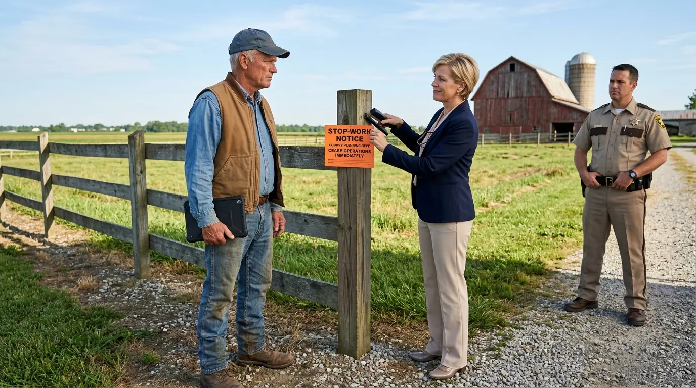
Marlene stepped back from the post and pointed toward the orange sheet. “That is a formal stop-work notice,” she said. “Your driveway reconstruction is inside a protected drainage corridor. No grading, stone placement, culvert work, tree removal, or machinery operation can continue until the committee determines compliance.” Arthur looked past her toward the excavator sitting forty yards uphill where his contractor had stopped work the evening before. The project was not dramatic. He was replacing a failing twelve-inch culvert, correcting several years of erosion along the driveway shoulder, and adding compacted stone to a private access road that led to his barn. The work had county erosion-control approval where required, and the contractor had called for utility markings before digging. Marlene knew all of that. She also knew Arthur had refused to sign a separate drainage agreement the committee had placed in front of him six months earlier.
Deputy Ortega cleared his throat. “Mr. Reed, just so everybody understands, I’m not here to enforce HOA rules. Ms. Cross called because she said there had been disagreement about access and notices being removed. I’m here to keep the peace and determine whether there’s any criminal issue.” Arthur nodded. “That’s all I expected.” Marlene glanced at Ortega, apparently dissatisfied by how little authority his presence added to her paperwork. “The association has enforcement rights under the covenants,” she said. “And the drainage corridor exists whether Mr. Reed likes it or not.” Arthur finally looked at the orange notice. Near the bottom, under the committee logo, was a small reproduction of a map with an orange shaded band sweeping diagonally across his parcel. According to that drawing, the band cut directly through the driveway.
Arthur did not pull the notice down. Instead, he raised his tablet. “Which drainage corridor?” Marlene stared at him. “The one on the map.” Arthur nodded. “I see the colored area. I’m asking what created it.” She pointed at the document as though the answer was obvious. “The Pine Hollow drainage map.” “Recorded where?” he asked. “With the association.” “That isn’t what I asked.” Deputy Ortega looked from Arthur to Marlene. She tightened her jaw. “Arthur, we have discussed this repeatedly. The development has protected drainage features established under the original stormwater plan. You were sent the map in March.” Arthur touched the screen of his tablet. “Yes. That’s why I started asking where this version came from.”
The disagreement had begun much earlier than anyone standing at the post wanted to admit. Pine Hollow was a thirty-seven-lot rural subdivision built in the foothills outside Asheville during the late 1990s, when developers had turned former cattle ground into wooded home sites with winding roads and oversized lots. The recorded plat showed several drainage easements, most following obvious terrain: a broad swale behind lots twelve through sixteen, a pipe easement beneath the main road, and a narrow strip along a seasonal drainage feature near the southern boundary. Arthur’s property, Lot 21, contained one recorded stormwater easement near its western edge. It did not cross his driveway. Arthur knew that not because he possessed some secret title document, but because when he bought the property eleven years earlier, he had ordered a survey and read the exceptions in his title policy instead of placing them unread into a closing folder.
Arthur was sixty-three now, a widower, and had spent thirty-five years working for utility contractors and survey crews across western North Carolina. He was not a licensed surveyor, and he corrected anyone who called him one. What he did know was how to read bearings, locate monuments, distinguish a conceptual line from a recorded easement, and recognize when someone had taken a useful map and asked it to carry more legal weight than it possessed. His wife, Rebecca, used to joke that Arthur could turn a scenic overlook into a conversation about right-of-way widths. After she died, he retired, moved his woodworking tools into the barn, and became the kind of neighbor who repaired mailboxes, sharpened mower blades, and generally preferred being left alone.
Marlene Cross had entered his life through committee work. She was fifty-eight, organized, intelligent, and capable of turning a volunteer position into something resembling a small regulatory agency. She had joined Pine Hollow’s board after repeated flooding damaged two downstream yards during a severe storm. The problem was real. Several original drainage structures had been undersized or poorly maintained. Driveway pipes had filled with sediment. New landscaping redirected runoff. One homeowner had built a retaining wall without considering where water would go after it reached the wall. Marlene pushed the board to take stormwater seriously, and in that respect Arthur agreed with her. Where they differed was in the point at which concern became authority.
Two years earlier, Pine Hollow hired a small engineering consultant to evaluate recurring drainage complaints. The firm produced a forty-six-page report identifying problem areas and recommending future improvements. The report included conceptual overlays showing where additional drainage corridors might be useful if the association later obtained easements from owners. The engineer wrote that distinction clearly: several shaded areas were recommended planning corridors, not existing legal easements. They were broad because they represented areas needing further survey, not precise property interests. Arthur had read the report when it was first circulated and thought little of it. Then, a year later, committee notices began referring to some of those recommended areas as though they already existed.
The first notice went to a retired teacher named Susan McBride, who wanted to replace a garden fence. The committee told her part of the fence sat inside a “protected stormwater corridor” and required relocation. Susan moved it because arguing seemed harder than moving posts. A second homeowner delayed building a small shed after Marlene produced a colored map showing a drainage strip near his proposed pad. He eventually abandoned the project. Nobody went searching through old engineering exhibits because the committee’s language sounded official, the colored lines looked technical, and most people wanted to avoid becoming the subject of a neighborhood email thread.
Arthur became interested only when the committee contacted him.
The letter arrived in March. Marlene wrote that planned driveway repairs required committee review because “the proposed construction lies partially within the Pine Hollow Protected Drainage Corridor identified on Map Revision 2024-C.” Attached was a PDF showing a broad orange ribbon cutting across the center of Lot 21. Arthur compared it to the recorded plat. The recorded easement stayed well west of the driveway. He compared it to his closing survey. Same result. Then he found the original engineering report. The orange ribbon resembled one of the consultant’s conceptual planning areas, but not exactly. It had been shifted east and narrowed, conveniently placing Arthur’s existing driveway inside it.
He emailed Marlene.
Please provide recording reference, plat book/page, deed reference, or easement instrument establishing the corridor shown on Map Revision 2024-C.
She replied the next afternoon.
The map derives from the approved Pine Hollow Stormwater Management Framework and has been adopted by the committee for enforcement purposes.
Arthur wrote back.
Adopted as a committee map or recorded as a property interest?
No answer came.
Instead, two days later, he received a proposed “Drainage Access and Maintenance Agreement” granting the association a thirty-foot easement across the middle of his parcel. The easement roughly matched the orange corridor.
That interested him even more.
If the association already possessed a protected drainage corridor, Arthur wondered, why did it need him to grant one?
He asked that question at the next board meeting.
Marlene answered from the end of a folding table in the clubhouse. “The document formalizes existing drainage rights and clarifies maintenance access.”
Arthur looked toward the other board members. “Existing under what instrument?”
Board president Tom Weller shifted uncomfortably. “Arthur, maybe we can take the title details offline.”
“I’m happy to.”
Marlene said, “This is not a courtroom.”
“No,” Arthur replied. “Which is why I’m asking before anybody acts like it is.”
The room became quiet.
Arthur did not raise his voice. He did not accuse Marlene of fraud. He did not threaten litigation. He simply declined to sign the new easement until the association identified the old one it supposedly formalized.
Then he applied for the driveway repair.
The county approved replacement of the failing culvert under the ordinary residential process. Arthur’s contractor, Jesse Pike, planned to remove the old pipe, install a properly sized replacement with stabilized inlet and outlet treatment, reshape the ditch, and regrade the gravel approach. The work followed the existing driveway alignment. No new road crossed the parcel.
The Pine Hollow committee denied its approval anyway.
Arthur’s attorney reviewed the covenants and gave him a cautious answer. The association had architectural review authority over certain exterior changes, and it could enforce recorded drainage easements. It could also regulate activities expressly covered by the covenants. But the committee could not create a new real-property easement simply by drawing one onto an internal map. Whether driveway work required separate HOA approval depended on the exact scope, prior approvals, and covenant language. The attorney advised Arthur not to treat the matter casually but also not to concede that “Map Revision 2024-C” had become a legal drainage corridor merely because the committee said so.
Arthur kept digging.
Not physically.
Digitally.
The PDF Marlene sent looked professionally prepared at first glance. North arrow. Parcel boundaries. Contours. Drainage shading. Revision block. Committee logo.
Arthur zoomed into the bottom right corner.
Pine Hollow Drainage Management Map — Rev. 2024-C.
Below it, in tiny gray type:
Base Data: Buncombe County GIS / Concept Drainage Layer PH-SWM-03.
Arthur searched for PH-SWM-03.
Nothing on the county website.
Nothing in recorded subdivision documents.
Nothing in the original consultant report.
Then he examined the PDF properties.
The creator field contained a piece of information Marlene probably never expected anyone to read:
Creator: Cross Land & Site Consulting — MCross
Arthur stared at it.
Marlene had once operated a small site-planning business with her husband, but as far as Arthur knew, she was acting for Pine Hollow as a volunteer committee chair, not as a retained engineer or surveyor.
That alone proved little. Someone had to create the map.
So Arthur kept looking.
Embedded inside the PDF was a web-map identifier.
He copied it into a browser.
A public ArcGIS Online page opened.
The title was:
Pine Hollow Drainage Working Draft
Owner:
CrossLandSite
Created fourteen months earlier.
Modified six weeks earlier.
Arthur opened the layer list.
Recorded easements.
County parcels.
Contours.
Culverts.
Then a layer called:
Proposed Drainage Acquisition Areas.
Arthur turned it off.
The orange corridor across his driveway disappeared.
He turned it on.
It returned.
He sat at his kitchen table for almost a minute without moving.
Then he opened the layer metadata.
The description read:
Conceptual areas for potential acquisition or voluntary easement negotiation. Not surveyed. Not for legal boundary determination.
Arthur took screenshots.
Still, he did not assume that ended the matter. Digital maps could be changed. Metadata could be misunderstood. He needed to know whether the association had formally adopted the proposal under some authority he had missed.
So he requested board records.
Meeting minutes arrived in pieces.
April.
May.
June.
Then a packet from the previous November.
One line caught his attention:
Committee discussed potential future drainage easement acquisition on Lots 18, 19, 21 and 22. No action taken pending owner outreach and funding review.
No action taken.
Arthur printed it.
A month later:
M. Cross presented updated drainage concept overlay to assist voluntary discussions with affected owners. Board requested cost estimates before considering formal program.
Again, no adoption.
Then February:
Chair Cross advised committee may use updated drainage overlay during review of projects potentially affecting stormwater flow. Board discussion followed. No motion.
Arthur read that twice.
A committee could use a map as information.
That did not transform proposed easement acquisition areas into existing easements.
He emailed his attorney.
The answer came back:
You have identified a meaningful discrepancy. Do not overstate it. The HOA may still have other covenant-based review arguments, but the map itself does not appear to establish a recorded drainage easement across the driveway. Preserve the source files and request clarification in writing.
Arthur did exactly that.
Marlene did not clarify.
She issued the stop-work notice instead.
That was why Arthur already had the tablet in his hand when she stapled orange paper to his post.
Deputy Ortega shifted his stance.
Arthur opened the PDF.
“Marlene, this is the map you’re relying on?”
“Yes.”
“Revision 2024-C?”
“Yes.”
“And the orange corridor is existing protected drainage area?”
“Yes.”
Arthur touched the screen.
The layer disappeared.
Marlene frowned.
“What did you just do?”
“Turned off the proposed-acquisition layer.”
Deputy Ortega moved slightly closer.
Arthur turned it back on.
The orange band reappeared.
“This map is public,” Arthur said. “The layer that crosses my driveway is called ‘Proposed Drainage Acquisition Areas.’”
Marlene’s face tightened.
“That is an internal naming convention.”
Arthur nodded.
“Could be.”
He opened the metadata.
“Then there’s this.”
Ortega read from the screen.
“Conceptual areas for potential acquisition or voluntary easement negotiation. Not surveyed. Not for legal boundary determination.”
Silence settled around the post.
Marlene stepped forward.
“That does not change the committee’s authority to protect drainage.”
Arthur looked at her. “I didn’t say it does.”
“Then stop pretending you found some loophole.”
“I’m asking why your notice calls a proposed voluntary easement area a protected corridor.”