Ofel now a super typhoon; Signal 5 up in Cagayan
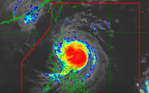
 RAMMB/US NOAA/Himawari 8
Typhoon Ofel intensified into a super typhoon on Thursday morning, PAGASA said, as it raised wind signal no. 5 over parts of Cagayan province.
At 4 a.m., Ofel was located 165 kilometers east of Tuguegarao, Cagayan, with maximum sustained winds of 185 kilometers per hour and gusts up to 230 kph. It is moving west northwestward at 15 kph.
It could landfall over eastern Cagayan or northern Isabela on Thursday afternoon, the state weather bureau said.
Evacuations, call for aid as Typhoon Ofel approaches PH
Typhoon Ofel will bring very destructive winds, torrential rains, and storm surge while traversing Northern Luzon.
Widespread serious damage, flooding, and landslidesare expected.
Another landfall is possible over Babuyan Islands late Thursday or early Friday.
Ofel will recurve past Babuyan, turn northwestward, and rapidly weaken into a remnant low while moving towards the southern Ryukyu Islands by early next week.
PAGASA at 8 a.m. raised the following wind signals.
Signal 5
185 kph winds expected in at least 12 hours
- Northeastern portion of mainland Cagayan (Santa Ana, Gonzaga)
Signal 4
118 to 184 kph winds expected in at least 12 hours
- Southeastern portion of Babuyan Islands (Camiguin Is.)
- Northern and eastern portions of mainland Cagayan (Santa Teresita, Ballesteros, Aparri, Camalaniugan, Buguey, Lal-Lo, Allacapan, Gattaran, Baggao, Peñablanca)
- Northeastern portion of Isabela (Maconacon, Divilacan, Palanan)
Signal 3
89 to 117 kph winds expected in at least 18 hours
- Rest of Babuyan Islands
- Rest of Cagayan
- Northern, central, and southeastern portions of Isabela (San Pablo, Delfin Albano, Ilagan City, Tumauini, Cabagan, Santa Maria, Santo Tomas, San Mariano, Dinapigue)
- Northern portion of Apayao (Flora, Santa Marcela, Luna, Pudtol, Calanasan, Kabugao), and the northern portion of Ilocos Norte (Pagudpud, Adams, Dumalneg)
Signal 2
62 to 88 kph winds expected in at least 24 hours
- Batanes
- Western and southern portions of Isabela (Quezon, Quirino, Mallig, San Manuel, Aurora, Cabatuan, City of Cauayan, Benito Soliven, Naguilian, Gamu, Burgos, Reina Mercedes, Luna, Roxas, Angadanan, Alicia, San Guillermo, Echague, Jones, San Agustin, San Mateo, San Isidro)
- Northeastern portion of Quirino (Maddela)
- Rest of Apayao, Kalinga
- Northeastern portion of Abra (Tineg, Lacub, Malibcong, Lagayan, San Juan, Lagangilang, Licuan-Baay, Daguioman)
- Eastern portion of Mountain Province (Paracelis)
- Eastern portion of Ifugao (Alfonso Lista)
- Rest of Ilocos Norte, and the northern portion of Aurora (Dilasag)
Signal 1
39 to 61 kph winds expected in at least 36 hours
- Rest of Isabela
- Rest of Quirino
- Nueva Vizcaya
- Rest of Mountain Province
- Rest of Ifugao
- Rest of Abra
- Northern portion of Benguet (Bokod, Mankayan, Kapangan, Atok, Kabayan, Kibungan, Bakun, Buguias, Tublay)
- Ilocos Sur
- Northern portion of La Union (Luna, Sudipen, Bangar, Santol, San Gabriel, Bagulin, Bacnotan, Balaoan, San Juan)
- Northern and central portions of Aurora (Casiguran, Dinalungan, Dipaculao, Maria Aurora, Baler, San Luis)
PEPITO
Meanwhile, Tropical Storm Man-yi continues to bear down on the Philippine area of responsibility.
At 3 a.m. Thursday, it was located 1,510 km east of Eastern Visayas, with sustained winds of 85 kph and gusts up to 105 kph. It was moving westward at 30 kph.
Man-yi may enter the PAR on Thursday evening and will be assigned the local name Pepito.
It may intensify up to super typhoon strength and make landfall at peak intensity over Bicol on Saturday, November 16, and cross Central Luzon on Sunday, November 17.
The track forecast however remains very uncertain and may continue to change in the next bulletins.

